| Date | Walk | Distance |
|---|---|---|
| 13 June 2010 | Monkham Hill (circular walk from Dunster) | 13.0 km (8.1 miles) |
| 12 June 2010 | Selworthy Beacon (Minehead - Porlock Weir) | 15.7 km (9.8 miles) |
| 20 August 2009 | Lype Hill (circular walk from Wheddon Cross) | 9.1 km (5.7 miles) |
| 19 August 2009 | Periton Hill (Dunster - Wootton Courtenay - Wheddon Cross) | 13.8 km (8.6 miles) |
| Plan | The plan for visiting the tops of all five Humps on Exmoor | - |
The plan for visiting the tops of all five Humps on Exmoor
Exmoor is a great place for walking. I've therefore decided to visit (or in some cases, revisit) the tops of all five HuMPs on Exmoor (listed below). The HuMPs are all conveniently located in the north-east quarter of the moor. [HuMP = Hundred Metre Prominence, a relative hill that has a drop of at least 100 metres on all sides, regardless of distance, absolute height or topographical merit.]
| Height (m) | Name | Grid Ref | Marilyn ? |
|---|---|---|---|
| 519 | Dunkery Beacon | SS891416 | Yes |
| 423 | Lype Hill | SS950371 | No |
| 381 | Monkham Hill | SS986394 | No |
| 308 | Selworthy Beacon | SS918480 | Yes |
| 297 | Periton Hill | SS947442 | Yes |
On previous visits I've walked up Dunkery Beacon (several times); I think I've visited Selworthy Beacon (it's very close to the South West Coast Path between Minehead and Porlock, a section I have walked); and I have certainly visited Lype Hill.
Update August 2009
I have friends who live on Exmoor, and who don't mind me wandering off for a walk when I visit them. Visiting them in August 2009 I managed to revisit Lype Hill, and visit Periton Hill for the first time.
This left only Monkham Hill remaining to be bagged (assuming I had visited Selworthy Beacon).
Update June 2010
This year's annual LUL old lags summer walking weekend was held on Exmoor (last year it was the Isle of Wight). We had been going to the Isle of Man, but found the Isle of Man TT finished on 11 June 2010, and we were concerned that accommodation might be difficult to find. I suggested Exmoor as an alternative, giving me the opportunity to visit a couple more HuMPs – in this case, Selworthy Beacon and Monkham Hill.
We took a circuitous route to Minehead, where we were staying at the Beach Hotel (train to Exeter, train to Barnstaple, bus to Lynton, cliff railway to Lynmouth, open-topped bus to Minehead). The Beach Hotel is a comfortable old-fashioned seaside hotel, ideally placed for the start of the South West Coast Path, buses and the West Somerset Steam Railway.
We returned home by taking the West Somerset Steam Railway to Bishops Lydeard, bus to Taunton and then train to London (with an excellent Pullman service late lunch).
19 August 2009: Periton Hill (Dunster - Wootton Courtenay - Wheddon Cross)
13.8 km (8.6 miles)

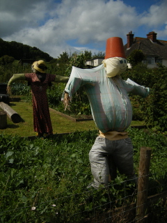
- Scarecrows, allotments in Dunster
I had lunch with friends in Dunster, and decided to walk back to Wheddon Cross (where I'm staying at the Rest and be Thankful Inn), taking in the summit of Periton Hill.

- View back to the Bristol Channel and the Quantocks
I followed the Macmillan Way West from Dunster to the summit of Periton Hill.
On the outskirts of Dunster the route passes Butter Cross (described by English Heritage as 'the transplanted stump of a medieval stone cross, once a meeting-place for butter-sellers') and then some allotments (with a couple of fine scarecrows), before climbing up the side of Grabbist Hill and onto the ridge leading to the summit of Periton Hill.

- Beech tree, Grabbist Hill
The walk along the ridge to the summit passes through some beautiful heathland, and has fine views across to Minehead and the Bristol Channel and back to the Quantocks.

- Trig point close to summit of Periton Hill
There is a trig point close to the summit (at 295 m above sea level), set on a concrete block inserted into a typical earth and stone boundary wall, with a fir plantation behind.
The actual summit is marked on the OS 1:25 000 map as a spot height of 297 m, inside the plantation. The exact summit is impossible to determine - the top is fairly level, and the plantation difficult (and unpleasant) to penetrate.

- View over Wootton Courteny, Dunkery Hill behind
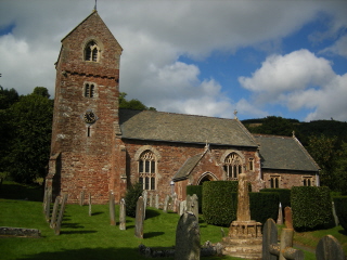
From the summit I continued along the Macmillan Way West to Wootton Courteny (stopping to look at the church) and Ford (where there is a ford over a tributary of the River Avill).

- Church, Wootton Courteny
From Ford I took the bridleway to Hole Cross, then followed Digland Lane and Spangate Lane (both tracks) to Spangate Land. From Spangate Land (a large field) I followed bridleways back to Wheddon Cross via North Combe and Ford Farm.
The weather was ideal - warm and sunny but not cloudless, with a strong breeze.

- View towards Wheddon Cross from Spangate Land
The Rest and be Thankful Inn is a excellent place to stay if you are visiting Exmoor. It serves local beers, including Exmoor Ale. Although Wheddon Cross itself isn't picturesque, it's a good centre for walking, and is served by buses.

- Rest and be Thankful Inn
20 August 2009: Lype Hill (circular walk from Wheddon Cross)
9.1 km (5.7 miles)

- Bridleway with bedrock surface
Today I only had a couple of hours spare for walking, so I decided to revisit Lype Hill, the highest point of the Brendon Hills. The route gives superb views over Exmoor, including the other four Exmoor HuMPs.

- Coleridge Way waymark
From Wheddon Cross I followed Popery Lane to Cutcombe Cross, then the bridleway that runs parallel to the B3224, a steady climb. There is a short section at the start of the bridleway where the surface is bedrock, worn smooth with use and as slippery as ice in wet weather (my water bottle still bears the dents from a fall on an earlier occasion). This is the route of the Coleridge Way, a comparatively new long distance path, 58 km (36 mile) long, from Nether Stowey to Porlock. Unfortunately, the Coleridge Way website appears to be defunct.

- View of Dunkery Beacon from White Moor
The summit of Lype Hill is marked by a trig point on a tumulus. Irritatingly, it is fenced off with barbed wire, and a small fir plantation has been established. I could see where some more determined walkers has squeezed between strands of barbed wire to touch the trig point, but not having anyone with me to hold the wire apart, and wearing expensive Gore-Tex waterproofs I didn't want ripped, I satisfied myself with a photo from outside the wire.

- Summit of Lype Hill
The actual bridleway over the summit does not exactly follow the route shown on the OS 1:25 000 map. It passes to the north of the trig point, rather than the south.

- View towards Selworthy Beacon from Lype Hill
From the summit, I returned to Wheddon Cross by the footpath along the field edge above Lype Brake, then (having crossed a minor road) through Hartcleeve Plantation and up to the lane leading to Putham Ford (Kersham Lane). The waymarking of the footpath has been considerably improved since I last did this walk.

- Putham
From Putham Ford I followed Putham Lane (a long hollow lane) back up to Cutcombe Cross, then walked through Cutcombe itself and back to Wheddon Cross.
The weather started overcast with occasional squalls, but ended as yesterday, warm and sunny but not cloudless, with a strong breeze.
12 June 2010: Selworthy Beacon (Minehead - Porlock Weir)
15.7 km (9.8 miles)

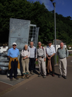
- Group photo in front of South West Coast Path monument
All seven of us set off on the walk (me, Bernie, Dan, Ian, Phil, Ted and Ron). The weather was perfect, warm and sunny, and stayed so all day. The start (or finish) of the South West Coast Path is marked by a large sculpture on the esplanade, of a pair of hands holding a map. There were two directions marked on the pavement for the start of the path, one pointing uphill, and one pointing along the coast. My old map showed the uphill route as the official route, and this is the one I had taken when I had last walked this section of the Coast Path. However, I had just bought a new map (Ordnance Survey OL 9), which shows a revised official route along the coast and over Culver Cliff, so this is the route we took.

- View towards Wales on the way to Selworthy Beacon
The new route joins the old route by tacking back from Greenaleigh Farm up to the start of the long ridge walk to Selworthy Beacon. Unfortunately Ron's back was playing up so he decided to turn back at this point.

- Selworthy Beacon trig point
The ridge walk to Selworthy Beacon is over rough moorland, passing areas of improved grazing. The bilberries were just ripening (I think that locally they are called whortleberries), and English Stonecrop and Pennywort (Navelwort) were out. I also found a patch of Common Dodder (Cuscuta epithymum), a parasitic plant forming a mass of thin red threads. It wasn't yet in flower.

- View to Dunkery Beacon
We turned off the Coast Path to follow a track for a short distance to reach the summit of Selworthy Beacon. The top is marked by a cairn and a trig point (stone built, rather than the usual concrete structure). The trig point carries a National Trust sign, a plate saying it forms part of the Ordnance Survey National GPS Network and another plate saying it has been ‘Adopted by C & D Pennington, Much Birch’.

- Hurlstone Combe
From the summit we returned to the Coast Path, with great views over Porlock Bay. About one and a half kilometres from the summit, the Coast Path drops steeply down Hurlstone Combe, the path running along the edge of scree filling the combe bottom. One or two people found this section rather hard going.

- Hurlstone Point, old coastguard lookout tower
At the bottom of the combe we stopped for lunch - sandwiches bought in Minehead. Some of us diverted the short distance to Hurlstone Point, with its old coastguard lookout tower and walked a short distance around the point to look at Selworthy Sand and Minehead Bluff. Selworthy Sand looked particularly inviting in the sun.

- Bossington Hill
From the bottom of Hurlstone Combe the Coast Path takes a track into the hamlet of Bossington (which has a tea room that looks as if it was once a pub). Here Dan and Ted decided to go on to Porlock (where they had a beer in the old Ship Inn).

- New salt marsh, Porlock Bay
The remaining four of us continued to Porlock Weir. The shingle ridge along Porlock Bay was breached in 1996, and a new salt marsh has been created as part of a ‘managed retreat’. The Coast Path follows the edge of the new marsh, which seems to be developing well, with characteristic salt marsh plants becoming established - the Perennial Sea Spurry (Spergularia media) was particularly plentiful. Its a rather dainty, pretty little plant with white, lilac tinged petals. The marsh is still dotted with the skeletal remains of trees and hedges killed by the influx of salt water.

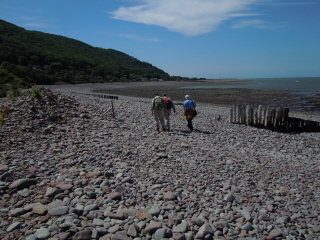
- Porlock Bay, approaching Porlock Weir
On the edge of the marsh there is a monument to the American airmen killed when a long range Liberator bomber crashed on 28 October 1942. The memorial has been moved from its original location behind the shingle ridge. There are two plaques - a simple hand punched plate ‘made from the remains of the aircraft’ and a more formal engraved plaque.
Just before reaching Porlock Weir the Coast Path runs along the top of the shingle bank for a short way - hard walking on a hot day. Once in Porlock Weir we were ready for a couple of pints before getting the bus back to Minehead, so we stopped at the Mariners Bar of the Ship Inn (not the same pub as the one Dan and Ted stopped at in Porlock). We had only started on our first pint when Ron turned up, having got the bus from Minehead.
An excellent walk in beautiful weather, with superb views and the opportunity to bag a Marilyn.

- Porlock Weir
13 June 2010: Monkham Hill (circular walk from Dunster)
13.0 km (8.1 miles)

- Dunster High Street
I’d devised a figure of eight circuit to visit Monkham Hill, completing my visits to the HuMPs on Exmoor. Much of the walk goes through Dunster Estate, part of the Crown Estate.

- Gallox Bridge over the River Avill
Only three of us decided to go on this walk (me, Bernie and Phil). The others chose a short walk along the sea to Dunster, where they spent some time before we all met up again to take an open-topped bus tour around Exmoor.
Those of us walking took the bus to Dunster Steep, then walked up to the town (which is very picturesque) and along the high street to pick up the route of the Macmillan Way West. This leaves the town by way of Gallox Bridge, a narrow stone packhorse bridge over the River Avill, dating from the 15th century.

- View to Dunkery Beacon from Bat's Castle
The Macmillan Way West climbs up the flank of Gallox Hill, then crosses Bat's Castle, an Iron Age hill fort enclosing 3.5 acres. From Bat's Castle the route drops down to Withycombe Hill Gate, then follows the ridge of Withycombe Hill. About a kilometre along the ridge we left the Macmillan Way West and turned south to pick up Stapling Lane. This passes Gupworthy Farm. Its surrounding fields were full of green tent-like sheds - for free range chickens I’d guess.

- Black Hill (north flank of Monkham Hill) from Withycombe Hill
At the end of Stapling Lane we continued along the bridleway up the side of Red Girts (a small steep valley) to reach a track that crosses the top of Monkham Hill. The top is marked on the map as Withycombe Common, and strictly Monkham Hill is the south slope of the common, and Black Hill is its north slope.

- View towards Watchet from Black Hill
The top is marked by a trig point, sitting on the edge of a tumulus. It’s a rather flat top, so the views are not great, though we could see Selworthy Beacon and the higher parts of Minehead.

- Monkham Hill trig point (Withycombe Common)
We paused at the top for water and a muesli bar, and then started the return trip by continuing westwards to a crossroads of paths and bridleways on the edge of the forest covering Croydon Hill, at the head of Long Combe (which separates Croydon Hill and Black Hill). There were some very shaggy cattle grazing at the edge of the common - I think for conservation purposes. Here we turned north, following the bridleway along the edge of the forest, dropping down to Withycombe Scruffets, an area of ancient semi-natural woodland. The trees are mostly coppiced oak.

- Cattle on Withycombe Common
From Withycombe Scruffets we followed a series of bridleways and footpaths back to Withycombe Gate. The actual route of some of these paths is not exactly as marked on the OS map, but there were no real navigational difficulties.

- Bridleway approaching Withycombe Scruffets
From Withycombe Gate we followed Park Lane, a broad track edged with stone banks, from which a series of regularly spaced beech trees were growing. When the lane turned east for Carhampton, we turned west to follow the footpath through Dunster Deer Park. The path gives the best view of Dunster Castle, and the deer park itself is rather fine (though grazed by cattle rather than deer).

- Park Lane
The footpath through the deer park took us back to Gallox Bridge, from where we retraced our steps into the town. We weren’t sure where the others had stopped for lunch, so we called in for a pint at the Stags Head Inn. It turned out that they had gone to the Luttrell Arms, and we met up at the bus stop. Here we took the No. 400 open-topped bus, which did a circuit Exmoor, finishing in Minehead.
The weather was occasionally overcast, and not as warm as Saturday, but still good for walking, if a bit cool for the bus ride.

- Dunster Park and Castle


